在合欢椅上高潮h,久久久久久久人妻无码中文字幕爆,美女扒开尿口和胸洗澡,国产在线精品一区在线观看

.
 

首頁 >> Optech ALTM 機載激光測量儀 >>

Optech ALTM 機載激光測量儀

Optech ALTM 機載激光測量儀


ALTM GEMINI
 

相關(guān)下載:

加拿大Optech機載激光測量儀ALTM彩頁  NEW!

Optech LIDAR 應(yīng)用

文獻(PDF格式)

宣傳彩頁(PDF格式)
ALTM Gemini   ALTM 3100EA   DASHMap Software
ZinView Quick Processing Software
ALTM NAV Software   REALM Software
100,000 Reasons to choose ALTM
ALTM 4K Digital Camera  ALTM NAV Software

應(yīng)用實例(PDF格式)
Pipeline Mapping  Powerline Corridor Mapping

規(guī)范(PDF格式)
ALTM 3100EA System Specifications
ALTM 3100 System Specifications

ALTM Gemini

A wide-area, high-altitude lidar mapping system incorporating the industry’s only fully-automated Continuous Multipulse (CMP) technology system.


Features

  • Dual beam divergence
  • Integrated video capture
  • Continuous Multipulse (CMP) technology
  • GPS, GLONASS and L-band capable
  • Waveform digitization option
  • Fully integrated imaging sensor options


ALTM Gemini DEM model

Benefits

  • Rapid coverage and data output capability
  • Unrestricted bank-angle capability while maintaining high data accuracy and integrity
  • Intensity capture with large dynamic range resulting in exceptional lidar image quality
  • Ability to operate efficiently in all application areas and altitudes with maximum data density
 

ALTM Orion M/C 200
NOW 200kHz


The ALTM Orion is the world’s smallest complete lidar mapping solution. combining high-density data collection with high-precision results. The very latest in technology innovation and system design, Orion enables cost-effective, reliable surveying in an ultra-compact design, while maintaining all the features and performance benefits you have come to expect.

Features

  • Ultra-compact sensor solution enabling small platform operation
  • Multi-peripheral imaging sensor capable
  • Latest laser technology featuring 200 kHz sampling capability
  • Automated roll compensation for straight data swaths below the collection platform
  • GPS, GLONASS and L-band ready


Benefits

  • Extremely narrow laser pulse widths enable high measurement precision and accuracy
  • Fully programmable FOV for incredible density
  • Intensity capture with large dynamic range resulting in exceptional lidar image quality and small target detection
  • Modular design approach for ease of installation, portability and serviceability
     
Orion-M Series
A mid-altitude, high-performance mapping sensor that provides stunning data precision and the accuracy typically demanded for engineering applications. Capable of collecting data at altitudes greater than 2000 m, Orion-M is the ideal choice when small payload platforms and/or multi-application flexibility is desired.
 
Orion-C Series
A low-altitude system for corridor applications where maximum object detail is required. Whether for its tremendous ground density capability (200 kHz effective) or its ability to operate with complete eye-safety at extremely low altitudes, Orion-C is the preferred choice of industry professionals.

Orion DEM

Orion DEM


ALTM Pegasus


ALTM Pegasus

A new benchmark in lidar mapping and active imaging technology.

ALTM Pegasus


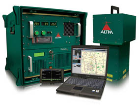
The ALTM Pegasus Advantage

The new ALTM Pegasus represents an open-concept technology platform enabling a variety of configuration options for specific applications and workflows, depending on user requirements. The first of these configuration options is the Pegasus HD400. Built specifically for high-definition mapping applications requiring high-density point sampling, Pegasus HD400 incorporates a wide field of view (FOV) with high range accuracy and precision.

  • Industry’s first multi-channel airborne laser terrain mapper
  • A technology alternative to multipulse, enabling a large operating envelope
  • Industry’s highest data sampling rate for high-definition mapping applications requiring maximum point density
  • A multiple look-angle configuration enabling improved canopy penetration
  • “Drop-in” sensor design for unrestricted use of advertised FOV in deep portal installations
  • High accuracy and precision independent of pulse rate, enabled by Optech’s iFLEX™ technology
  • Fully embedded digital camera options ranging from 5 to 60 MP
  • The latest in tightly-coupled inertial and Virtual Reference System processing technology, enabling steep turns and an extended GPS baseline


A technology platform that takes lidar mapping to the next level:

  • Dense, high-quality data sets
  • Highest sampling rate in the industry
  • Mulitiple look angles
  • Wide operational envelope
  • Fully embedded digital camera solutions from 5 to 60 Megapixels


Lidar DEMs


中翰3D產(chǎn)品部技術(shù)通訊:

加拿大Optech LIDAR技術(shù)通訊(第1期)CMS技術(shù)與應(yīng)用
加拿大Optech LIDAR技術(shù)通訊(第2期)LYNX技術(shù)與應(yīng)用
加拿大Optech LIDAR技術(shù)通訊(第3期)邀請函
加拿大Optech LIDAR技術(shù)通訊(第4期)中英文對照
加拿大Optech LIDAR技術(shù)通訊(第5期)LYNX數(shù)據(jù)實例
加拿大Optech LIDAR技術(shù)通訊(第6期)火星探測
加拿大Optech LIDAR技術(shù)通訊(第7期)LYNX客戶應(yīng)用實例

加拿大Optech LIDAR技術(shù)通訊(第8期)HD新產(chǎn)品

加拿大Optech LIDAR技術(shù)通訊(第9期)LYNX在鐵道測量的應(yīng)用
加拿大Optech LIDAR技術(shù)通訊(第10期)LYNX在鐵道測量的應(yīng)用
加拿大Optech LIDAR技術(shù)通訊(第11期) 在地質(zhì)方面的應(yīng)用

加拿大Optech LIDAR技術(shù)通訊(第12期)電力線特征提取

加拿大Optech LIDAR技術(shù)通訊(第13期)Optech發(fā)布新的Lynx(山貓)V200系統(tǒng)
加拿大Optech LIDAR技術(shù)通訊(第14期)ADS鐵路隧道

加拿大Optech LIDAR技術(shù)通訊(第15期)ADS鐵路隧道

加拿大Optech LIDAR技術(shù)通訊(第16期)3D激光測量技術(shù)應(yīng)用

加拿大Optech LIDAR技術(shù)通訊(第17期)機載lidar考古應(yīng)用

加拿大Optech LIDAR技術(shù)通訊(第18期)

加拿大Optech LIDAR技術(shù)通訊(第19期)

加拿大Optech LIDAR技術(shù)通訊(第20期)

加拿大Optech LIDAR技術(shù)通訊(第21期)利用Lynx移動測圖系統(tǒng)進行堤岸測量

加拿大Optech LIDAR技術(shù)通訊(第22期)ALTM Aquarius 水陸兩用航測激光測量系統(tǒng)

德國Z+F高精度三維掃描儀技術(shù)通訊(第1期)新產(chǎn)品發(fā)布
德國Z+F高精度三維掃描儀技術(shù)通訊(第2期)全面測試


中翰3D產(chǎn)品部 聯(lián)系方式:


上海:021-64433366 張福祥經(jīng)理 18606925001
北京
:010-62650905 曹友經(jīng)理 13910781851
南寧:0771-5766421 蔣仁軍經(jīng)理 18977097125
LYNX和航測產(chǎn)品專項負責(zé):劉勇強經(jīng)理 010-62565779、15901348850

Z+F產(chǎn)品專項負責(zé)
:李學(xué)飛經(jīng)理 010-62650905 、13810334745 


總部地址:云南省昆明市盤龍區(qū)鉑金大道50號創(chuàng)意中心1幢15樓(云南映象城市公園廣場寫字樓招商銀行旁大廳電梯上15樓全測精達科技)
電話:0871-65651270   傳真:0871-65651270   技術(shù)服務(wù)熱線:13700644714   服務(wù)QQ:372403198   E-mail:372403198@qq.com 

Copyright© 2011-2021 云南全測精達科技有限公司 All right reserved   網(wǎng)站建設(shè):昆明邦凱網(wǎng)絡(luò) 
   
主站蜘蛛池模板: 光泽县| 沂南县| 奉新县| 祁东县| 黑水县| 山东| 滦平县| 安陆市| 九龙城区| 内黄县| 曲阜市| 淄博市| 绩溪县| 油尖旺区| 枣庄市| 大理市| 公安县| 乌拉特后旗| 黎平县| 沛县| 宜丰县| 资阳市| 汤阴县| 富源县| 东光县| 马关县| 瑞安市| 吉首市| 巨鹿县| 东兰县| 驻马店市| 承德市| 嘉黎县| 尚志市| 中山市| 枣强县| 秦安县| 淳安县| 武宣县| 渑池县| 黄梅县|